
Source: 📸 Credit: Jen Hayner, Edgerton, WI
Apr 18, 2025, 8:01 AM CST
Share
MADISON, Wis. (CIVIC MEDIA) – Severe thunderstorms woke up Wisconsin Friday morning dropping massive hail, shattering windshields and damaging roofs.
As southern Wisconsin was waking up for work and school Friday morning… huge hail came crashing down on them in a severe thunderstorm warning.
The storm struck Platteville first, with reports of 2.75″ hail, the size of baseballs. As moved east rapidly, it smacked Belmont, Brooklyn, Evansville and Edgerton with significant and damaging hail at 2.5″ or bigger.

If caught in a storm with hailstones that large, stay inside. Get away from windows and wait safely until it’s over. If you are driving, go to a nearby gas station or parking garage with a roof to park under.
Reports are coming in of broken windshields from the Platteville area and wrecked siding. If you were in the path of this storm, you probably need a new roof, too. Call your insurance company and beware of “storm chaser scams” and fake companies coming to your door after the storm.
That was just round one. Now the southern part of the state will flirt with 70 degrees and become unstable again. A cold front is sitting north and will sweep south, sparking up more severe weather Friday evening.
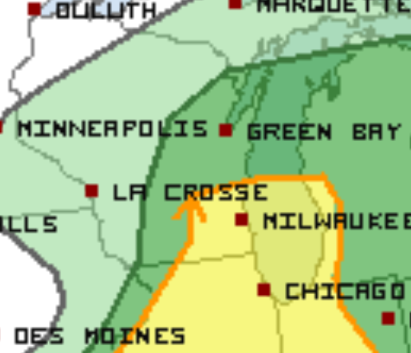
The Storm Prediction Center has put southeast Wisconsin in a slight risk for more massive hail, high winds and heavy downpours. These look to start after the peak heating of the day, after 4 PM until about 7 PM.

More From Brittney Merlot
Want More Local News?
Civic Media
Civic Media Inc.
The Civic Media App
Put us in your pocket.

